The Third Walk

At JMU, State and Local Government (POSC 302) is part of the Public Administration curriculum. I took the class with Mr. Robert Sullivan, a retired employee of the Harrisonburg zoning office, and a part-time professor at JMU. Part of Mr. Sullivan’s class is three walks around areas of Harrisonburg, where we learned about local zoning and got real-world examples of some of the urban planning theories we studied in class. The walks are a great way to learn about planning and zoning, because instead of just studying and memorizing things, we’ve got some concrete examples in the community right around us to reference. On the third walk, we visited the Old South High Street neighborhood as well as a nearby industrial area. I took pictures on the walk to use for reference purposes for the follow-up paper assignment. Follow the arrows on this map from MapQuest showing where we went.
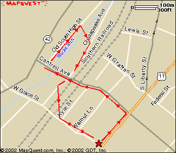
Map of our route

So let’s leave Maury Hall and continue on to South Main Street…


South Main Street is mixed-use. It contains general business uses, as well as high-density residential (seen below).

South Main Street is mixed-use. It contains general business uses, as well as high-density residential (seen below).

South Main Street is mixed-use. It contains general business uses, as well as high-density residential (seen below).  South Main Street is mixed-use. It contains general business uses, as well as high-density residential (seen below).


Turning off of South Main Street and heading towards High Street on Cantrell Avenue, we passed over the Talmage R. Cooley bridge, built in the 1960s as part of infrastructure improvements.

Turning off of South Main Street and heading towards High Street on Cantrell Avenue, we passed over the Talmage R. Cooley bridge, built in the 1960s as part of infrastructure improvements.


From Cantrell Avenue, we went down a small set of stairs, and entered a cul-de-sac at the end of Old South High Street, part of a residential neighborhood. Old South High Street is so named because it used to be South High Street up until the 1960s when South High Street was widened. Since widening this street was not feasible, requiring demolition of the entire neighborhood, it was instead determined to build the widened South High Street along the edge of the neighborhood and close off what became Old South High Street with a cul-de-sac.  From Cantrell Avenue, we went down a small set of stairs, and entered a cul-de-sac at the end of Old South High Street, part of a residential neighborhood. Old South High Street is so named because it used to be South High Street up until the 1960s when South High Street was widened. Since widening this street was not feasible, requiring demolition of the entire neighborhood, it was instead determined to build the widened South High Street along the edge of the neighborhood and close off what became Old South High Street with a cul-de-sac.

From Cantrell Avenue, we went down a small set of stairs, and entered a cul-de-sac at the end of Old South High Street, part of a residential neighborhood. Old South High Street is so named because it used to be South High Street up until the 1960s when South High Street was widened. Since widening this street was not feasible, requiring demolition of the entire neighborhood, it was instead determined to build the widened South High Street along the edge of the neighborhood and close off what became Old South High Street with a cul-de-sac.


This no-parking sign is technically meaningless, since the owner of the property at this location put the sign up in front of a public street, in order to reserve a parking space for himself on the street. Thus if I wanted to park in the same spot, he would have no legal recourse.

This no-parking sign is technically meaningless, since the owner of the property at this location put the sign up in front of a public street, in order to reserve a parking space for himself on the street. Thus if I wanted to park in the same spot, he would have no legal recourse.


Behind the no-parking sign, and what Mr. Sullivan is gesturing towards, is what is described as a "paper alley", so called because it's technically a public alley, but only on paper, as this is definitely not a public alley in practice. In fact, this public alley has a horseshoe pit in it.

Behind the no-parking sign, and what Mr. Sullivan is gesturing towards, is what is described as a “paper alley”, so called because it’s technically a public alley, but only on paper, as this is definitely not a public alley in practice. In fact, this public alley has a horseshoe pit in it.


Most of the Old High Street neighborhood is single-family residential (above), though there is some high-density residential (below left), consisting of apartments where parking has replaced the front yard, and also medium-density residential (below right), in the case of this duplex where there is a couch in front of one of the entrances (strange, don't you think?).

Most of the Old High Street neighborhood is single-family residential (above), though there is some high-density residential (below left), consisting of apartments where parking has replaced the front yard, and also medium-density residential (below right), in the case of this duplex where there is a couch in front of one of the entrances (strange, don’t you think?).

Most of the Old High Street neighborhood is single-family residential (above), though there is some high-density residential (below left), consisting of apartments where parking has replaced the front yard, and also medium-density residential (below right), in the case of this duplex where there is a couch in front of one of the entrances (strange, don't you think?).  Most of the Old High Street neighborhood is single-family residential (above), though there is some high-density residential (below left), consisting of apartments where parking has replaced the front yard, and also medium-density residential (below right), in the case of this duplex where there is a couch in front of one of the entrances (strange, don't you think?).


Beyond the houses is the new South High Street, now a dual-divided highway. Across South High Street is Harrisonburg High School.

Beyond the houses is the new South High Street, now a dual-divided highway. Across South High Street is Harrisonburg High School.


Up the street, this brick structure used to be an industrial facility, but has since closed its doors.

Up the street, this brick structure used to be an industrial facility, but has since closed its doors.


From here, we went down to Mongers Lumber, an industrial facility built over and around Blacks Run. The waterway seen above is Blacks Run, and the wooden bridge which we are standing on below is built over Blacks Run.

From here, we went down to Mongers Lumber, an industrial facility built over and around Blacks Run. The waterway seen above is Blacks Run, and the wooden bridge which we are standing on below is built over Blacks Run.

From here, we went down to Mongers Lumber, an industrial facility built over and around Blacks Run. The waterway seen above is Blacks Run, and the wooden bridge which we are standing on below is built over Blacks Run.


The class continues along Chesapeake Avenue, heading toward Grace Street.  The class continues along Chesapeake Avenue, heading toward Grace Street.

The class continues along Chesapeake Avenue, heading toward Grace Street.


Continuing along Chesapeake Avenue, we find more industrial area, and then passed over the railroad tracks, and under the Talmage R. Cooley bridge back to Grace Street.

Continuing along Chesapeake Avenue, we find more industrial area, and then passed over the railroad tracks, and under the Talmage R. Cooley bridge back to Grace Street.

Continuing along Chesapeake Avenue, we find more industrial area, and then passed over the railroad tracks, and under the Talmage R. Cooley bridge back to Grace Street.


Finally, we checked in with Mr. Sullivan again to ask any questions we may have had, and we were off!

Finally, we checked in with Mr. Sullivan again to ask any questions we may have had, and we were off!

Comments are closed.